Petrovaradin fortress
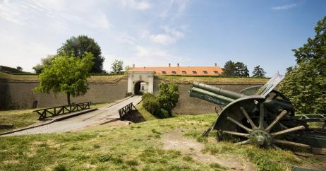
The Petrovaradin Fortress, exceptional work of the 18th-century fortification engineering, is one of the largest, most complex and best preserved artillery bastions in this part of Europe. It spreads over the northern slopes of Fruška Gora, on the right bank of the Danube. With the apex of 125 m above the sea level, it has the dominant position in the southeastern part of the Panonian Plain. It covers the area of over 100 ha, has a 5200-meter-long outer defence line and a complex system of underground military galleries with mine and listening tunnels, distributed at four levels, with 16000 meters of the total length. Being the last in the series of fortifications using all the advantages of the exceptional geostrategic position, unique in style and concept, it unifies the coherence and monumentality of the military architecture with the natural environment. At present, the fortress is mostly demilitarized; however, it is the trademark of the contemporary city, which owes its origin and rise to the fortress itself.
The fortress was put under national protection in 1948, and in 1991 it was proclaimed a cultural heritage property, a cultural and historical complex of great importance.
Exceptional natural position of the Petrovaradin rock has always been an inviting place for settlement. This is attested by the results of preventive archaeological research which has revealed the presence of the Palaeolithic culture (the Middle Palaeolithic), the remains from the New Stone Age have been confirmed, as well as the material remains of all the well-known cultures characteristic of the south Panonian region. The mentioned researches confirmed the data of the historical sources which note the arrival of the Romans on the Danube in the 1st century AC and their presence until the second half of the 4th century. In addition, confirmed were the assumptions about the size and shape of a Hungarian medieval fortification with the Cistercian monastery and the Church of the Holy Virgin Mary, built between 1237 and 1252, and the Turkish presence in this area (1526-1687). The Polish-Ottoman War (1683-1699) marked the beginning of the end of the Turkish rule in this area.
After an unsuccessful siege of Vienna and the defeat of Turks, Austrian army entered Petrovaradin in 1687, following a series of victories. The need for the establishment of a newly-formed southern border of the kingdom demanded a modern artillery fortress to be built, in order to protect Buda and Vienna from the surge of the Turkish army. The demolition of the medieval fortification commenced in 1690 already, and the building of the modern fortress started on October 18th, 1692, when the cornerstone was laid by Prince Croy, the delegate of Emperor Leopold I. The fortress’ location in the core of the Austrian-Turkish conflict, as well as difficult historical circumstances inside and outside the empire itself, directly influenced the works on the complex, so the building process lasted until 1780 with interruptions. When the construction was finished, the fortress covered the area of 112 ha, with a garrison numbering 4000 people armed with 400 canons, and with gunpowder warehouses of 20 t capacity. At the beginning of the 19th century, it was the strongest and the best-equipped fortress in the Austrian Empire. The moment it was finished, its role of a war fortification started to decline. Petrovaradin then became administrative, army, spy and information centre with a military command, while the fortress became an advance guard of the Austrian Empire on the side of the Balkan Peninsula. Barracks, the Air Force School and the command of the River Flotilla of Armed Forces were located on the fortress, in the Kingdom of Yugoslavia, between the two World Wars. After the Second World War, the fortress remained in possession of the army, until 1951, when the majority of the complex was handed to civil government to administer.
The Petrovaradin Fortress was built by designs of Austrian military engineers Mathias Kaisersfeld, Luigi Ferdinando Marsigli, and Michael Wamberg, who was also the first builder of the fortress. It was designed according to the most modern achievements of European fortification architecture of the time, based on the rules of the Vauban's system of bastion lines. The assets of the terrain morphology were used to the full in all parts of the fortress, while potential weaknesses were eliminated by the utilization of technical solutions which provided full efficiency of the defence system. At the same time, having in mind the long building period, the complex was enhanced and modernized in accordance with the development of arms and military techniques, applying the latest achievements of defence techniques.
The composite complex was developed on three interconnected height levels simultaneously. It consists of the Upper Fortress (Obern Festung), Hornwork (Hornwerk) and Lower Fortress (Wasserstadt), while two outer fortifications, by the river, the Bridgehead (Bruckschanze) on the left bank of the Danube and the Island Fortification (Inselshanze), today no longer exit. All the parts of the complex are unified by a unique outer defence line (envelope) which consists of interconnected structures of the fortification defence system: counterguards, ravelins, lunettes and caponiers.
The Upper Fortress is located on the apex of the Petrovaradin rock, in the place of the former medieval fortification. It is shaped by five bastions (St. Leopold, St. Innocent, St. Joseph, Ludwig, upper and lower, and St. Theresa) connected by curtain walls. On the southeast side, between the Leopold and Innocent bastions, there is the highest structure of the fortification – cavalier. The access to the highest plateau of the Upper Fortress is provided by three lavishly shaped arch entrance gates: the Ludwig, Castle and Leopold gates, and there are two more gates in the ravelins: the Molinari and Charles VI gates. Structures that have retained their authentic shape are: the Officers’ Pavilion, Leopold Powder Magazine, Food Warehouse, Arsenal, Long Barracks and Simple Barracks, Clock Tower, as well as the Great War Well.
Hornwork is on the left side, shaped by two bastions (St. Charles and St. Elizabeth), which are connected to the bastion line of the Upper and Lower Fortress by the right and left wing walls. The plateau of the Hornwork can be accessed by two main communication gates, on the east and west side. The following have been preserved in this location: the One-Floor Barracks, St. Elizabeth's Powder Magazine, water station, guard-houses, artillery sheds and paddocks. The exceptionally developed outer defence line of this part of the complex forms a triple belt of trenches. A complex system of underground mine galleries with listening tunnels, built between 1768 and 1776 by the design of Major Schroeder, has been preserved on the inside of the fortification structures.
The Lower Fortress is located on the very curve of the Danube, leaned against the rock and the walls of the Upper Fortress. It is bounded by pentagonal bastioned trace consisting of three bastions (St. Francis, St. Theresa and St. Joseph) and two semi-bastions (St. Charles and St. Benedict), connected by curtain walls. Inside the walls of the main bastioned trace there is Lower Town, characterized by dense urban block structure with orthogonally positioned street network and preserved military, civilian and sacral structures built during all the phases of the building of the complex. The oldest structures are sacral buildings: the former Jesuit monastery of St. George (1701-1734) and the Franciscan monastery (until 1720), which was transformed into a military hospital in 1786, and finally into the command building of the fortress (Generalathaus). Practically all the formerly most important buildings of military and civil administration and the most beautiful residential houses of high-ranking officers and fortress administrators are located along the main street, as well as around the square. They were predominantly built during the 18th century, in baroque style. Specific military buildings are situated inside the walls of the Lower Fortress, near the clearly differentiated urban structure of Lower Town (powder houses, barracks, warehouses), as well as St. Paul’s Orthodox Chapel. Two monumental main gates have been preserved in the locality: the Belgrade Gate and the New Gate, in addition to two postern gates, and the gate of the trenches in the Wasserstadt ravelin. The main bastion line of the Lower Fortress, on the Danube side, is protected by a complex outer defence line consisting of a triple belt of trenches.
The process of the Petrovaradin Fortress revitalization started right after the military administration got the rule over the complex. With higher or lower intensity, the fortress restoration and the change of original purposes of the fortress’ buildings and areas has been taking place to this day, in accordance with the precise vision of the fortress complex as the city’s cultural, education, tourist and recreational centre. Over time, functions of buildings have been changing, as well as their users. Therefore, the area of the Upper Fortress features: the City Museum in the Arsenal building, Historical Archive in the Simple Barracks and in one part of the Long Barracks, including a warehouse in Leopold’s Powder Magazine, a hotel in the Long Barracks, restaurants, drawing rooms of the city protocol in the Officers’ Pavilion, pastry shops, cafés and old crafts in the Food Warehouse and the Simple Barracks. The Academy of Arts is situated on the Hornwork, in the One-Floor Barracks, Water Station and St. Elizabeth’s Powder Magazine. The Novi Sad artists have been given the use of the buildings and casemates; therefore, now there are over one hundred art studios in the fortress. The casemates of the Upper Fortress have been adapted for the Tapestry Gallery, Planetarium and Jazz Club, while the Great War Well has been restored. One part of the underground military galleries of the Upper Fortress, precisely 900 metres, is presented to the public as part of the City Museum’s offer. Equestrian and archery club are located on the Hornwork, in the casemates and trenches below St. Catherine’s ravelin and St. Elizabeth’s bastion.
At the same time, the area of the Lower Fortress has retained its original purpose, still having mainly military function, with the Military Hospital that came into existence in the Franciscan Monastery, and has been working continually since 1786. The civilian part of the town is mostly residential, with a small number of businesses for the needs of the local people. The works on the Upper Fortress, the renovation/revitalization of buildings, have not been performed in this area, except for sporadic interventions. The social category of residential low-standard housing units (as a consequence of the changes that took place after the Second World War), unresolved proprietary status, and intensive transit traffic through the very core of Lower Town, have prevented the comprehensive renovation process in this exceptionally valuable baroque complex. Nevertheless, Lower Town, once the very core of the fortress complex, a military and administrative centre as well as representative urban and architectonic unit, has retained its authentic form and specific ambient and spirit of the period of its origination.

Contact information
Phone:
+381 21 420-066
Address:
Trg slobode 1
21101 Novi Sad
Republic of Serbia